What is geospatial? Learn the clear definition, what the geospatial field includes, who uses it, and why location data is one of the most powerful dimensions of modern analysis.
In 2010, Haiti’s earthquake killed over 150,000 people. Within 48 hours, volunteer mappers around the world were working from satellite imagery to map Port-au-Prince street by street, producing the most detailed map the city had ever had, in real time, for search and rescue teams who had never used a map of it before.
That response was geospatial thinking under pressure. Location data, spatial tools, and people who understood how to use them together.
But geospatial isn’t just for crises. It’s the layer of thinking that connects information to place, and it’s embedded in more of the decisions around you than most people realize.
Contents
- 1 What Is Geospatial?
- 2 How Is Geospatial Different From Geography?
- 3 What Does the Geospatial Field Include?
- 4 Who Uses Geospatial Information?
- 5 Why Does Location Matter So Much?
- 6 How Is Geospatial Different From Spatial?
- 7 How Do You Start Exploring the Geospatial Field?
- 8 Wrap Up
- 9 FAQ
- 9.1 What does geospatial mean in simple terms?
- 9.2 What is the difference between geospatial and geographic?
- 9.3 What are the main components of the geospatial field?
- 9.4 Why is location data so important?
- 9.5 What is the difference between geospatial and spatial?
- 9.6 What careers are available in the geospatial field?
- 10 Keep Building Your Geospatial Foundation
What Is Geospatial?
Geospatial refers to anything that relates to, is defined by, or can be associated with a specific location on Earth’s surface.
The word combines two roots: “geo,” meaning Earth, and “spatial,” meaning relating to space and position. Put them together, and you get a single concept: information that is anchored to a place on our planet.
But geospatial is more than a definition.
It’s a field, a discipline, and increasingly a foundational layer of how the modern world operates. Think of it as the ecosystem surrounding location-based information. The data that captures where things are, the technology that collects and processes that data, and the analysis that turns it into decisions.
Here’s an analogy that might help.
A spreadsheet full of hospital admissions data tells you something about public health. Add a location to every row: a neighborhood, a coordinate, a postal code.
It suddenly becomes clear that the same data reveals patterns: which communities have the highest rates of preventable illness, which areas are furthest from care, and where the next clinic should be built.
The data didn’t change. The location did all the additional work.
That’s what geospatial means in practice.
Location is the variable that connects information to the real world.
The geospatial field is the discipline built around collecting, managing, analyzing, and communicating that connection.
How Is Geospatial Different From Geography?
This is the first question most people ask, and it’s a fair one. The two concepts are closely related but not interchangeable.
Geography is an academic discipline.
It studies the Earth, including its physical features, climate systems, human populations, cultural landscapes, and the relationships between people and their environments. Geography asks “what is here, how did it get here, and why does it matter?” It’s a science of observation, description, and explanation.
Geospatial is broader and more applied.
It includes everything geography encompasses but extends well beyond it into technology, engineering, data science, and operational decision-making. Where geography explains the world, geospatial equips people to observe it, measure it, model it, and act on it: at scale, in near real-time, using digital tools and computational methods.
A geographer might study why a particular city grew where it did.
A geospatial analyst might build a geospatial model that predicts where the next urban growth boundary should be drawn, using satellite imagery, population data, infrastructure layers, and flood risk maps. Same underlying interest in place and location. Very different methods, tools, and outputs.
In professional practice, “geospatial” has largely replaced “geographic” as the standard descriptor for the technology and data side of the field. You’ll see it in job titles, platform names, industry organizations, and government programs worldwide.
It signals a focus on applied, technology-enabled location analysis rather than traditional academic geography.
What Does the Geospatial Field Include?
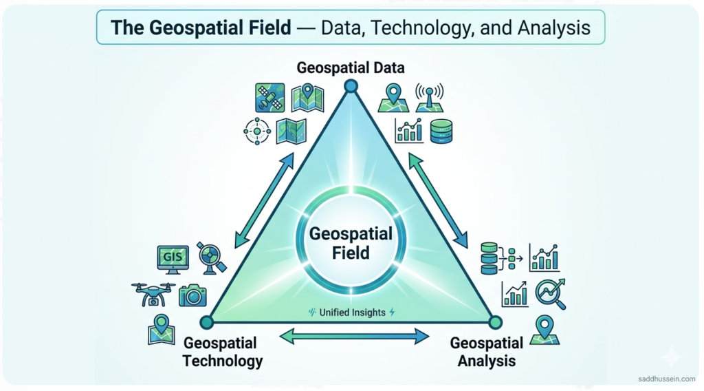
The geospatial field is built on three interconnected pillars. Understanding each one and how they relate gives you a map of the entire discipline.
Geospatial Data
Geospatial data is the raw material of the field.
It’s any information that has a location component:
- coordinates,
- boundaries,
- satellite imagery,
- elevation values,
- street addresses,
- GPS tracks,
- statistics linked to geographic units.
Geospatial data comes in two primary forms.
Vector data represents discrete features — points, lines, and polygons that define locations, routes, and boundaries.
Raster data represents continuous surfaces — grids of values covering an area, like satellite imagery, elevation models, or temperature maps.
Every geospatial workflow starts here, with data that tells you where something is and what attributes it carries.
The geospatial data article in this series covers types, formats, properties, and sources in full detail. For now, the key point is this: without location-referenced data, there is no geospatial analysis.
Geospatial Technology
Geospatial technology is the tooling layer: the platforms, systems, and instruments that collect, store, process, visualize, and distribute geospatial data.
This is a broad category that includes:
- GIS software like QGIS and ArcGIS,
- remote sensing satellites and sensors,
- GPS and GNSS positioning systems,
- spatial databases,
- web mapping platforms, and
- emerging technologies like AI-driven spatial analysis and digital twins.
Technology is what makes modern geospatial work possible at scale.
A century ago, geospatial work meant manual surveying, hand-drawn maps, and paper archives.
Today, it means processing terabytes of satellite imagery in cloud environments, building real-time location intelligence dashboards, and running predictive spatial models across continental extents.
This geospatial technology article covers the full technology stack in depth — sensors, software, platforms, and where the field is heading next.
Geospatial Analysis
Geospatial analysis is the process of extracting meaning from location data. It’s the bridge between raw data and actionable insight — using spatial relationships, patterns, and models to answer questions that location makes possible.
Where is flood risk highest in this watershed? Which neighborhoods are underserved by public transit? How has land cover changed across this region over the past twenty years?
These are geospatial questions, and geospatial analysis is the discipline that answers them — through overlay analysis, proximity modeling, change detection, spatial statistics, and dozens of other methods.
The geospatial analysis article digs into methods, tools, and applications in full. Here, the important point is that analysis is what gives the data and technology their purpose.
Who Uses Geospatial Information?
This is where most people are surprised. Geospatial isn’t a niche field for cartographers and satellite engineers. It’s embedded in how dozens of industries operate — and the list keeps growing.
Environmental Science and Conservation
Environmental scientists use geospatial data and tools to monitor ecosystem health, track deforestation, map species distributions, model climate change impacts, and design protected area networks. Remote sensing satellite data provides the wall-to-wall, time-series coverage that no ground-based monitoring program could match. Conservation organizations use geospatial analysis to prioritize where limited resources will have the greatest ecological impact.
Urban Planning and Government
City planners, regional agencies, and national governments rely on geospatial tools to manage land use, design infrastructure, assess environmental risk, allocate public services, and respond to emergencies. GIS is essentially the operating system of modern urban governance — from zoning decisions to disaster preparedness to census mapping.
Agriculture and Precision Farming
Farmers and agricultural researchers use satellite-derived vegetation indices, soil maps, and weather data layers to monitor crop health, optimize irrigation, and estimate yield before harvest. Precision agriculture — the practice of managing fields at sub-field resolution based on spatial variability — would be impossible without geospatial data and analysis.
Disaster Response and Humanitarian Organizations
When floods, earthquakes, or conflict displace populations, geospatial teams produce the maps that guide response operations — identifying affected areas, locating population centers, mapping accessible routes, and tracking the distribution of aid. Organizations like the UN Office for the Coordination of Humanitarian Affairs maintain dedicated geospatial units that activate within hours of major crises.
Defense and Intelligence
Geospatial intelligence — the analysis of location data to support national security and military operations — is one of the oldest and most sophisticated applications of the field. Satellite imagery analysis, terrain modeling, and real-time positioning are foundational to modern defense and intelligence operations worldwide.
Logistics and Transportation
Every time a delivery route is optimized, a supply chain is mapped, or a fleet is tracked in real time, geospatial technology is doing the work. Logistics companies use location intelligence to reduce fuel consumption, minimize delivery windows, and respond dynamically to disruptions. The routing algorithms in navigation apps are geospatial analysis running continuously in the background.
Public Health and Epidemiology
Disease surveillance, health facility planning, environmental exposure mapping, and epidemic response all depend on geospatial analysis. Mapping where disease clusters occur, which populations lack access to care, and how environmental conditions correlate with health outcomes requires the same foundational tools — location data, GIS software, and spatial analysis methods.
Business and Location Intelligence
Retailers use geospatial analysis to select store locations based on demographic data, competitor proximity, and traffic patterns. Insurance companies model spatial risk to set premiums. Real estate platforms use location data to value properties. Anywhere a business decision involves “where” — which is nearly everywhere — geospatial thinking is relevant.
Why Does Location Matter So Much?
It’s worth pausing to ask the deeper question: why is location such a powerful dimension of information?
The most-cited statistic in the geospatial field is that up to 80 percent of all data has a location component. That number is impossible to verify precisely, but the underlying point is sound: an enormous proportion of the information humanity generates is connected to somewhere on Earth — a transaction, a health event, a sensor reading, a social post, a vehicle movement, a weather observation.
Location matters because the world is not uniform.
Disease rates vary by neighborhood. Flood risk varies by elevation. Crop yields vary by soil type. Crime patterns vary by street. Consumer behavior varies by proximity to amenities. In almost every domain, understanding where something happens is as important as understanding what happened or how often.
As I’ve observed across many analytical projects, adding a location dimension to a dataset consistently reveals patterns that non-spatial analysis misses entirely.
Two hospitals with identical admission rates can be serving completely different populations with completely different levels of access. Two farms with identical crop yields can be achieving them under completely different stress conditions. Location is the context that makes data interpretable.
This is the foundational insight that drives the entire geospatial field: where matters. And the discipline of geospatial is the systematic practice of taking that insight seriously.
How Is Geospatial Different From Spatial?
A brief but important distinction — especially for readers coming from academic geography, statistics, or quantitative research backgrounds.
“Spatial” is the older, broader term. It appears in mathematics, physics, cognitive science, and academic geography to describe anything relating to space and position — not necessarily Earth’s surface specifically. Spatial statistics, spatial cognition, spatial reasoning — all of these use “spatial” in a general sense that doesn’t imply GIS tools or Earth observation technology.
“Geospatial” is more specific. It anchors spatial concepts explicitly to Earth’s surface and the technologies — GIS, remote sensing, GPS, spatial databases — used to observe and analyze it. In professional practice across the GIS, mapping, and Earth observation industries, “geospatial” is the standard term.
How Do You Start Exploring the Geospatial Field?
Understanding what geospatial means is the first step. The next step is experiencing it directly — and the barrier to entry has never been lower.
Step 1: Open a web GIS platform
Go to Google Maps, ArcGIS Online, or download QGIS for free. Navigate to a place you know well and explore what location data looks like in practice — street networks, land parcels, elevation, satellite imagery. You don’t need to do any analysis yet. Just get comfortable with the idea of information organized by location.
Step 2: Browse a free geospatial dataset
Visit Natural Earth (naturalearthdata.com) for free vector and raster datasets at global scale. Explore OpenStreetMap (openstreetmap.org) for crowd-sourced location data covering the entire planet. Check USGS Earth Explorer for satellite imagery and elevation data. Download something. Open it. Look at what location data actually contains.
Step 3: Follow the content cluster
The Better Mapmaker series on geospatial fundamentals takes you deeper into each pillar of the field. The geospatial data article covers data types, formats, and sources in detail. The geospatial technology article maps the full tool ecosystem. The geospatial analysis article covers methods and workflows. Read them in sequence for a complete foundation, or jump to whichever pillar is most relevant to your current work.
Wrap Up
Geospatial is not a software category or a technical specialty. It’s a way of understanding and engaging with the world through the lens of location. It’s one of the most broadly applicable analytical frameworks in modern science, industry, and governance.
The field rests on three pillars: geospatial data as the raw material, geospatial technology as the tooling layer, and geospatial analysis as the process that turns location information into knowledge.
Together, these three components power applications ranging from precision agriculture to disaster response, from urban planning to wildlife conservation, from public health to global climate monitoring.
Location matters because the world is not uniform. And the geospatial field exists to help us understand, measure, and act on that non-uniformity — systematically, rigorously, and at scale.
Once you see the world geospatially, you can’t unsee it.
FAQ
What does geospatial mean in simple terms?
Geospatial means relating to a specific location on Earth’s surface. The word combines “geo” (Earth) and “spatial” (relating to position and space). In practice, geospatial refers to any data, technology, or analysis that is defined by or connected to a geographic location — from GPS coordinates and satellite imagery to land cover maps and demographic data linked to neighborhoods.
What is the difference between geospatial and geographic?
Geographic relates to geography as an academic discipline — the study of the Earth’s physical features, human populations, and the relationships between them. Geospatial is broader and more applied, encompassing the tools, technologies, and analytical methods used to collect, process, and act on location-based information. In professional practice, geospatial is the standard term for the technology and data side of location-based work.
What are the main components of the geospatial field?
The geospatial field has three interconnected components: geospatial data (location-referenced information including coordinates, satellite imagery, and vector boundaries), geospatial technology (the tools and platforms used to collect, process, and visualize that data — GIS software, remote sensing, GPS, spatial databases), and geospatial analysis (the methods used to extract meaning and support decisions from location data).
Why is location data so important?
Location data matters because the world is not uniform — disease rates, flood risk, crop yields, consumer behavior, and almost every other phenomenon vary significantly by place. Adding a location dimension to a dataset reveals spatial patterns that non-spatial analysis misses. Up to 80 percent of all data is estimated to have a location component, making geospatial thinking relevant across nearly every field and industry.
What is the difference between geospatial and spatial?
Spatial is a broader term used in mathematics, statistics, physics, and academic geography to describe anything relating to space and position — not necessarily Earth’s surface. Geospatial is more specific, anchoring spatial concepts explicitly to Earth’s surface and the technologies used to observe and analyze it. In professional GIS and Earth observation contexts, geospatial is the standard term.
What careers are available in the geospatial field?
The geospatial field supports a wide range of careers including GIS analyst, remote sensing specialist, cartographer, geospatial data scientist, spatial developer, geodetic surveyor, geospatial project manager, and location intelligence analyst. These roles exist across environmental agencies, government, defense, agriculture, logistics, technology companies, NGOs, and academic research institutions. Demand for geospatial skills has grown steadily as location data has become central to decision-making across industries.
Keep Building Your Geospatial Foundation
Now that you have a clear picture of what geospatial means and what the field encompasses, the natural next steps are the companion articles that go deeper into each pillar.
The geospatial data article covers what location data actually looks like — types, formats, properties, and sources.
The geospatial technology article maps the full ecosystem of tools from GIS software to satellite sensors to emerging AI platforms.
The geospatial analysis article takes you into the methods and workflows that turn location data into decisions.
If you have questions about the geospatial field — where to start, which tools to learn, or how geospatial applies to your specific work — drop a comment below. Let’s figure it out together.
Happy mapping!